I-25 Webcams in Fountain, Colorado

I-25 highway webcams in Fountain, CO, at South Academy Blvd, milepost 135.3

I-25 highway webcams in Fountain, CO, 2.0 miles S of CO 16/Mesa Ridge Pkwy, milepost 130.2

I-25 highway webcams in Fountain, CO, at Sante Fe Ave, milepost 127.85

I-25 highway webcams in Fountain, CO, 0.6 miles N of Ray Nixon Rd, milepost 125.2

I-25 highway webcams in Fountain, CO, 0.6 miles south of Ray Nixon Rd, milepost 124

I-25 highway webcams in Fountain, CO, at Midway Ranch Rd, milepost 121.7

I-25 highway webcams in Fountain, CO, 0.1 miles south of Rancho Colorado Blvd, milepost 118.75
I-25 Webcams in Fountain, Colorado
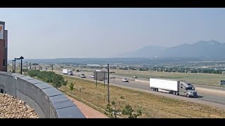
The I-25 webcams in Fountain, Colorado provide real-time views of traffic flow and road conditions along a key stretch of interstate just south of Colorado Springs. This section of I-25, generally between mileposts 128 and 135, connects Fountain with Colorado Springs to the north and Pueblo to the south, serving as an important corridor for commuters, regional travel, and commercial trucking.
Key webcam locations in Fountain include I-25 at Mesa Ridge Parkway (milepost ~132.50) and I-25 at Santa Fe Avenue (milepost ~128.80). These cameras offer views of both northbound and southbound traffic, allowing drivers to monitor conditions across this busy section of highway.
Traffic flow in Fountain is typically moderate but can increase during peak commute hours and travel periods. This corridor carries a mix of local commuters, military traffic from nearby installations, regional travel, and commercial vehicles. Congestion can occur near major interchanges, particularly during morning and evening rush hours.
Road conditions in this area are generally stable but can still be impacted by weather. Winter storms can bring snow and icy conditions, while strong winds across the open terrain can create blowing snow and reduced visibility. Rain and summer thunderstorms may also affect driving conditions and traffic flow.
Seasonal travel conditions vary throughout the year. Winter brings the highest risk of hazardous driving due to snow and wind, while spring and summer bring increased travel and occasional storms. The webcams provide a clear, up-to-date look at roadway conditions and weather visibility throughout Fountain.
Whether traveling north toward Colorado Springs or south toward Pueblo, these I-25 webcams in Fountain offer valuable insight into traffic flow, road conditions, and weather visibility to help you plan your trip safely.
I-25 Corridor through Fountain and Southern El Paso County
I-25 is one of the most important north-south highways in the United States, and in Fountain, Colorado, it serves as a major transportation route connecting Colorado Springs with southern Colorado. The highway runs directly through the area, providing access to local communities and regional destinations.
Fountain is located in El Paso County and sits just south of Colorado Springs. Key interchanges such as Mesa Ridge Parkway and Santa Fe Avenue provide access to residential areas, commercial zones, and nearby military installations.
The corridor features relatively flat terrain compared to areas further north along the Palmer Divide, allowing for steady traffic flow. However, weather conditions can still impact driving, particularly during winter when snow and wind can reduce visibility.
Traffic along this section of I-25 includes a mix of local commuters, long-distance travelers, and commercial trucking. The highway is an important route for both regional travel and freight movement across southern Colorado.
Mileposts between 128 and 135 are key reference points for monitoring conditions in the Fountain area. This stretch of I-25 is an important link between Colorado Springs and Pueblo.
Overall, the I-25 corridor in Fountain is a vital part of the state’s transportation network, and webcams in this area provide a valuable tool for monitoring real-time traffic and weather conditions.




Why Use This Webcam
- Check real-time traffic flow on I-25 in Fountain
- Monitor road conditions before traveling between Colorado Springs and Pueblo
- View current weather visibility including snow, wind, or storms
- Identify congestion near Mesa Ridge Parkway and Santa Fe Avenue
- Plan safer and more efficient travel along I-25
Frequently Asked Questions
Where is this webcam located?
These webcams are located along I-25 in Fountain, Colorado, typically between mileposts 128 and 135 near major interchanges.
Can I check road conditions with this webcam?
Yes, the webcams allow you to view current road conditions including traffic, snow, ice, wind, and visibility.
Does the webcam show weather conditions?
Yes, they provide real-time views of weather conditions such as snowfall, rain, wind, and overall visibility.
Is the webcam live?
Most I-25 webcams update frequently, offering near real-time views of traffic and road conditions.
Colorado Highway Webcams
Colorado Interstate Highway Webcams
US Highway Webcams in Colorado
Colorado State Highway Webcams
More Colorado Webcams