Mammoth Cave National Park Webcam – Green River
Mammoth Cave National Park Webcam – Green River Valley
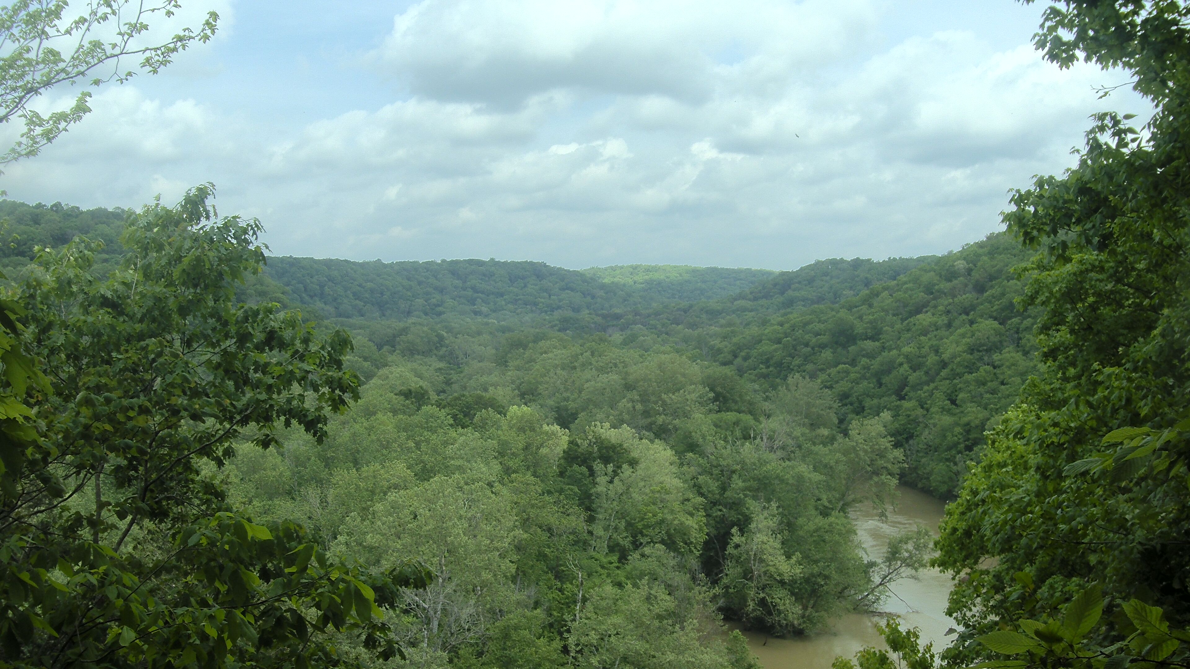
The Mammoth Cave National Park Webcam looks north-northwest across the Green River Valley from the Houchin Meadow area of central Kentucky. This is an above-ground landscape camera—not a view inside Mammoth Cave—and it shows an important part of the environment that helped create and continues to influence the cave system beneath the park.
The camera overlooks a broad, forested valley dominated by rolling hills and hardwood trees. Because the image includes a large expanse of sky and distant ridgelines, it is useful for checking visibility, cloud cover, fog, rainfall and changing foliage. The National Park Service operates the camera as part of an air-quality monitoring station, and the still image generally updates about once an hour.
Seasonal changes are particularly noticeable here. Spring brings fresh green foliage and unsettled weather, while summer produces a dense canopy that can partially obscure the contours of the valley. Autumn adds broad bands of yellow, orange and red across the hills. In winter, bare trees reveal more of the underlying terrain, and occasional snow or frost can transform the view.
Although the famous cave passages are hidden below the surface, this webcam reveals the living landscape above them: forest, weather and water working together across one of the world’s great karst regions.
Watch the Green River Valley Through the Seasons
The Green River Valley provides a far better webcam subject than a dark cave passage would. Its distant hills make changes in atmospheric visibility easy to recognize, while the forest creates a clear record of Kentucky’s seasons.
On humid or rainy days, haze and low clouds may soften or completely obscure the farthest ridges. Clear, dry air produces a sharper view with greater separation between the layers of hills. The camera can also reveal approaching weather, morning fog and the reduced visibility associated with wildfire smoke or elevated airborne particles.
The Green River is not prominently visible from every frame, but it is central to the landscape. It flows through the park and acts as the base-level stream for the Mammoth Cave System. Groundwater moves through sinkholes and underground passages before emerging at springs along the river. At times, river water can also push back into the cave system, carrying sediment, nutrients and organic material into underground habitats.
That relationship makes the webcam view more meaningful than a simple woodland panorama. The hills and valleys above ground are connected directly to the passages, rivers and springs below.
About Mammoth Cave National Park
Mammoth Cave National Park protects the longest known cave system in the world, with more than 426 miles of surveyed passages. Exploration continues, so the documented length grows as researchers establish connections and map newly reached sections.
The cave developed within thick layers of limestone beneath a more erosion-resistant sandstone cap. Rainwater absorbed carbon dioxide from the air and soil, becoming mildly acidic as it moved through cracks in the rock. Over immense spans of time, that water dissolved the limestone and enlarged fractures into an extraordinary network of shafts, canyons, tubes and rooms.
The Green River helped control this process by establishing the level toward which groundwater drained. As the river cut its valley deeper, underground drainage shifted downward and left older cave passages dry above newer ones. The result is a multi-level system with passages formed during different stages of the region’s development.
Mammoth Cave is not simply a geological attraction. People have interacted with it for thousands of years. Indigenous people explored parts of the cave, collected minerals and left behind remarkably preserved evidence of their presence. During the 1800s, enslaved guides—including Stephen Bishop, Mat Bransford and Nick Bransford—helped explore the cave and shaped visitors’ understanding of it. Their knowledge became fundamental to the early history of Mammoth Cave tourism.
The national park encompasses nearly 53,000 acres above and below ground. Its protected surface includes the Green and Nolin rivers, hardwood forest, sinkholes, springs, historic communities and more than 80 miles of trails. Mammoth Cave is also recognized as a UNESCO World Heritage Site and an International Biosphere Reserve.
The webcam’s location in the Green River Valley highlights this broader park. Mammoth Cave cannot be understood as an isolated underground attraction—the forest, rainfall, watershed and river seen or represented in this view are all parts of the same connected system.
Above Ground and Below Ground at Mammoth Cave
A cave tour is the park’s signature experience, but Mammoth Cave offers substantially more than underground rooms and passageways.
Below ground, tours vary in length, difficulty and character. Some emphasize the enormous scale and human history of the cave, while others visit tighter passages, vertical shafts or formations such as those in the Frozen Niagara area. Visitors should select a tour based on walking distance, stair count and physical demands—not simply its name. Cave tours frequently sell out, making advance reservations the safest choice.
Above ground, trails lead through forests, along ridges and toward overlooks, springs and historic sites. The Green River and Nolin River support paddling, fishing and wildlife habitat. More than 60 miles of backcountry trails on the park’s north side accommodate hikers, horseback riders and, on designated routes, mountain bikes.
Wildlife is often easier to encounter above ground than inside the cave. White-tailed deer, wild turkeys and numerous woodland birds inhabit the park, while the rivers support unusually diverse communities of fish and freshwater mussels. Bats remain among the park’s best-known animals, but Mammoth Cave also protects specialized cave species adapted to permanent darkness.
Planning a Visit to Mammoth Cave National Park
Cave City and Park City are the principal interstate gateways, with access from I-65. The visitor center, cave-tour departure points and most developed services are on the south side of the Green River.
Cave tours are offered throughout the year, but the selection changes seasonally. Reservations are strongly recommended, particularly during summer, weekends and school vacations. Even during hot weather, cave interiors remain cool, so bring a light jacket and wear sturdy walking shoes.
Spring and fall are especially attractive for combining a cave tour with hiking and scenic drives. Summers are warm and humid, while winters are quieter and can reveal more of the valley’s terrain after the leaves fall.
The Green River divides the park. A small vehicle ferry normally provides a direct connection between the north and south sides, but its operation can be interrupted by high or low water. Check its status before relying on it as part of your route.
Why Use the Mammoth Cave National Park Webcam?
- See current conditions across the Green River Valley.
- Check cloud cover, fog and general visibility.
- Watch spring leaf-out and autumn color develop.
- Observe how the forested hills change throughout the year.
- Preview above-ground weather before hiking or sightseeing.
- Compare clear days with humid, hazy or smoky conditions.
- See the landscape associated with the world’s longest known cave system.
- Check a current image before traveling to the park.
Mammoth Cave National Park Webcam FAQs
Where is the Mammoth Cave webcam located?
The camera is associated with the Houchin Meadow air-quality monitoring area inside Mammoth Cave National Park in Kentucky.
What does the webcam show?
It shows the forested Green River Valley and surrounding hills. It does not provide a view inside Mammoth Cave.
What direction does the camera face?
The National Park Service identifies the view as looking north-northwest.
Is the webcam live?
It is a regularly updated still-image webcam rather than continuous streaming video. The image generally refreshes about once per hour.
Can the webcam help check air quality?
The image can reveal visible haze, fog and smoke, but appearance alone cannot measure pollution. The camera is part of an NPS monitoring site that also collects air-quality and weather data.
Why is the Green River important to Mammoth Cave?
The Green River is the principal surface drainage for the area and has strongly influenced the cave’s formation. Groundwater from the cave system eventually emerges through springs and enters the river.
How large is Mammoth Cave?
More than 426 miles of connected passageways have been surveyed, making Mammoth Cave the longest known cave system in the world. Exploration and mapping continue.
Can visitors enter Mammoth Cave without a tour?
Access depends on the current cave-tour schedule. Ranger-led and limited self-guided options may be available, but visitors should check the schedule and reserve ahead because tours commonly sell out.
More Kentucky Webcams
See More Kentucky
Explore More Kentucky Webcams
See more of the Bluegrass State with our Kentucky Webcams, featuring live views of cities, highways, lakes, weather and scenic destinations. You can also explore our National Park Webcams and Kentucky Weather Webcams for additional current conditions.