
Dry Falls Webcam – Sun Lakes, Washington
Dry Falls Webcam – Sun Lakes-Dry Falls State Park
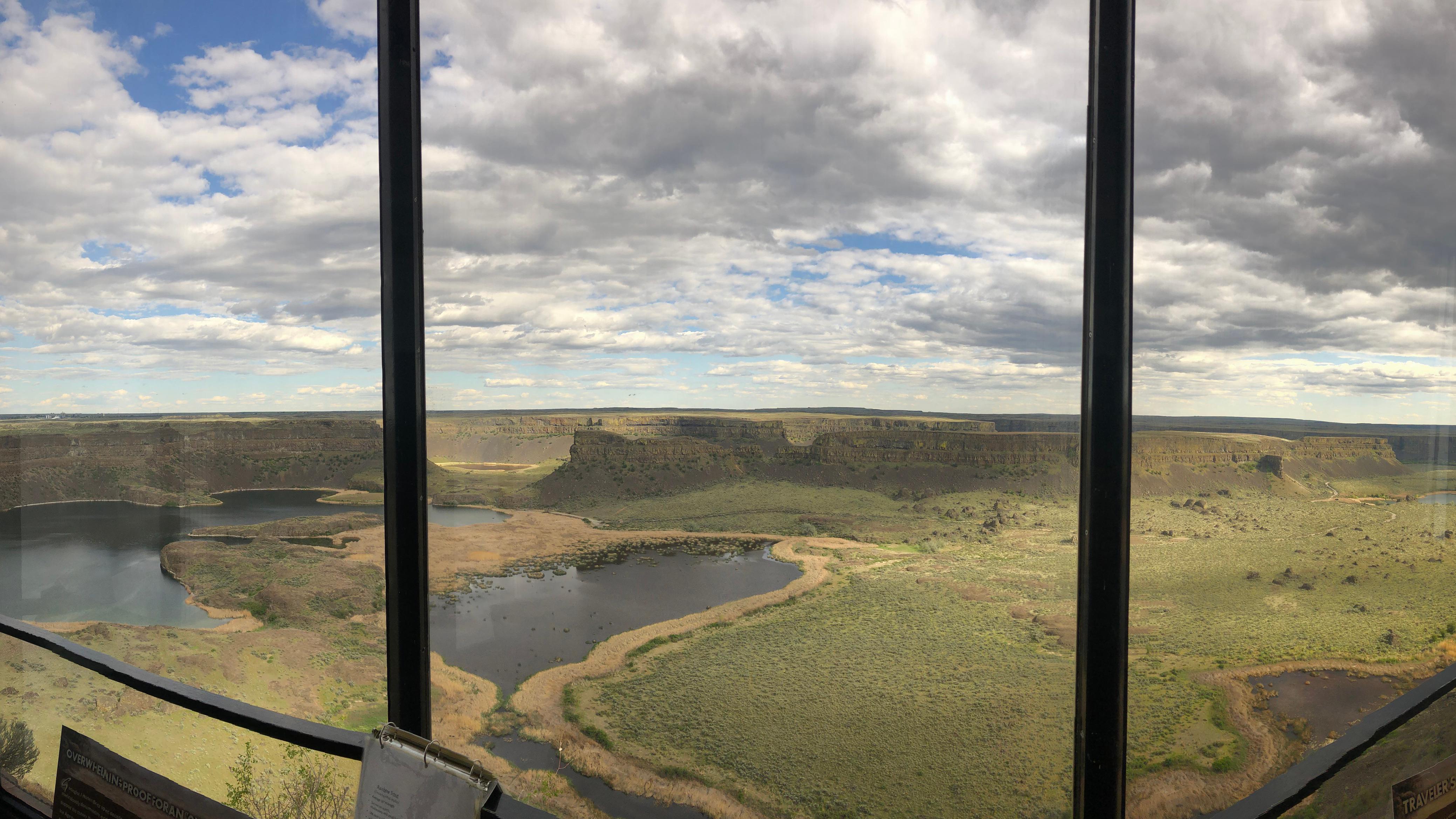
The Dry Falls Webcam looks across one of the most extraordinary Ice Age landscapes in Washington. Positioned at the Dry Falls Visitor Center near Coulee City, the camera overlooks the immense cliff left behind by repeated floods that swept across the Columbia Plateau near the end of the last Ice Age.
The former waterfall spans approximately 3.5 miles and rises about 400 feet above the lakes and broken terrain below. Its scalloped cliff, isolated rock formations and steep-walled channels are remnants of a waterfall once far larger than Niagara Falls.
Because the camera covers such a broad landscape, it is useful for checking visibility, cloud cover and general weather around Dry Falls. Clear conditions reveal the scale of the cliff and the coulee stretching beyond it. Low clouds, haze, rain or snow can soften or conceal the more distant features.
The view changes noticeably with the light. Morning and evening shadows emphasize the contours of the cliffs, while bright midday sun can make the exposed basalt appear almost flat. Snow occasionally highlights the ledges and surrounding uplands during winter. In spring, patches of green briefly interrupt the otherwise dry, sagebrush-dominated landscape.
Watch Dry Falls and the Grand Coulee
Although no river pours over Dry Falls today, the webcam shows abundant evidence of moving water. The curved cliff face marks the former edge of an enormous waterfall, while the deep depressions below were scoured by the force of water and sediment. Several of those depressions now contain small lakes.
Dry Falls formed through repeated erosion rather than a single steady waterfall lasting thousands of years. Ice Age floodwater traveled through the Grand Coulee, plunged over the cliff and carved into the basalt. As erosion undermined the waterfall’s edge, sections collapsed and the falls gradually retreated upstream.
The modern overlook stands near the final position of that retreat. From the webcam’s elevated perspective, visitors can see the dry cataract, plunge pools and fractured terrain as one connected geological feature.
Seasonal changes are more subtle here than in a forested park. Snow, spring vegetation, summer haze and autumn’s muted grasslands alter the colors, but the exposed basalt remains the defining feature throughout the year.
About Sun Lakes-Dry Falls State Park
Sun Lakes-Dry Falls State Park protects more than the famous overlook. The park extends through a portion of the lower Grand Coulee, where cliffs, lakes, basalt formations and dry channels preserve evidence of the Ice Age Floods.
Near the end of the last Ice Age, an ice sheet blocked the Clark Fork River in what is now Montana, creating Glacial Lake Missoula. When the ice dam failed, an enormous volume of water surged across northern Idaho and eastern Washington. This cycle occurred repeatedly, with floodwater stripping away soil, cutting channels into basalt and reshaping large portions of the Columbia Plateau.
At Dry Falls, water hundreds of feet deep rushed through the Grand Coulee and over an enormous cataract. Continued erosion caused the falls to retreat approximately 20 miles from its earlier position near Soap Lake. The remaining 400-foot-high, 3.5-mile-wide cliff provides one of the clearest demonstrations of the floods’ scale.
The landscape initially puzzled geologists. J Harlen Bretz argued during the 1920s that catastrophic flooding had created Washington’s Channeled Scablands. His interpretation challenged the prevailing preference for slow geological processes and faced years of resistance. Evidence eventually confirmed that enormous floods had shaped the region. The Dry Falls Visitor Center was dedicated to Bretz in recognition of his work.
The park is part of the Ice Age Floods National Geologic Trail, a network extending across Montana, Idaho, Washington and Oregon. It is also within the Grand Coulee National Natural Landmark.
The webcam location matters because the visitor-center overlook provides one of the most complete views of the former waterfall. What appears at first to be a collection of cliffs and small lakes becomes much easier to understand when viewed as the remains of a single enormous cataract.
See Washington Park Webcams



Reading the Dry Falls Landscape
The curved recesses along the cliff are individual sections of the former waterfall. During the floods, water plunged over several connected cataracts rather than one perfectly straight edge.
Below the cliff, the dark lakes occupy deep basins known as plunge pools. These depressions were excavated as falling water, rock and sediment struck the ground with tremendous force. With the floodwater gone, groundwater and seasonal runoff now collect in portions of the scoured terrain.
The flat-topped formations standing apart from the main wall are remnants of basalt that resisted erosion longer than the surrounding rock. The extensive coulee beyond the falls marks the route taken by the floodwater.
This is what makes the webcam more interesting than an ordinary desert overlook: nearly every major feature in the image is evidence of the same series of events. The cliff is the former waterfall, the lakes occupy its plunge pools and the surrounding channels record the movement of floodwater through the basalt.
Planning a Visit to Dry Falls
Sun Lakes-Dry Falls State Park is located along Washington State Route 17, south of Coulee City. The visitor-center overlook provides the easiest view of Dry Falls and allows visitors to see essentially the same landscape shown by the webcam.
Spring and fall generally offer comfortable conditions for exploring the overlooks and surrounding park. Summers are hot, dry and exposed, with limited shade away from developed areas. Winter can bring freezing temperatures and occasional snow or ice.
Beyond the overlook, the park includes lakes, hiking areas, fishing, paddling, camping and access to the lower Grand Coulee landscape. Park Lake is the largest developed recreation area, while Deep Lake lies farther into the coulee beneath steep basalt walls.
Carry drinking water and sun protection during warm weather. Services are limited outside Coulee City and other small communities, and mobile coverage can be inconsistent within the coulee.
Why Use the Dry Falls Webcam?
- See current visibility across the Dry Falls cliff.
- Check cloud cover and general weather near the overlook.
- Watch morning and evening shadows define the basalt formations.
- Observe occasional winter snow across the coulee.
- See seasonal color changes in the surrounding grasslands.
- Preview the landscape before visiting the state park.
- Examine the former waterfall and its plunge pools.
- Watch one of the signature locations on the Ice Age Floods National Geologic Trail.
Dry Falls Webcam FAQs
Where is the Dry Falls Webcam located?
The camera is at the Dry Falls Visitor Center in Sun Lakes-Dry Falls State Park near Coulee City, Washington.
What does the webcam show?
It overlooks the approximately 3.5-mile-wide Dry Falls cliff, the former plunge pools below it and the surrounding Grand Coulee landscape.
Is water flowing over Dry Falls?
No. The enormous floods that created the waterfall ended thousands of years ago. Small lakes now occupy some of the deep basins below the dry cliff.
How large is Dry Falls?
The remaining cliff is approximately 400 feet high and 3.5 miles wide. The ancient waterfall was several times wider than Niagara Falls.
What created Dry Falls?
Repeated Ice Age floods swept across eastern Washington, forcing tremendous volumes of water through the Grand Coulee. The water eroded the basalt and caused the waterfall to retreat upstream.
Is the webcam live?
The webcam displays a current still image rather than continuous streaming video. The image updates periodically.
Can visitors reach the webcam location?
Yes. The Dry Falls Visitor Center and overlook are reached from Washington State Route 17. Access to the visitor-center building and its services may vary seasonally.
What is the best time to visit Dry Falls?
Spring and fall typically offer the most comfortable temperatures. Summer provides long daylight hours but can be extremely hot, while winter may bring snow and icy conditions.
More Washington Webcams

See More Washington State!
Explore more live views across the Evergreen State with our Washington Webcams, Washington Mountain Webcams, Washington Lake Webcams and National Park Webcams.